SIAE: How Medellín’s Utilities Company Built a Platform to See Beyond Security
The Environmental Analysis Information System (SIAE), is an in-house platform created by Grupo EPM (Empresas Públicas de Medellín) that integrates security, social, political, and territorial data to guide strategic decisions across Colombia and beyond.
Decades of Service, Generations of Impact
Grupo EPM (Empresas Públicas de Medellín), comprising 47 companies operating in Colombia, Chile, Panama, El Salvador, and Guatemala, has provided public services since 1955 and currently serves more than 40 million people. Its core infrastructure, which forms the backbone of daily community life, includes 105 energy generation systems (solar parks, thermal and hydroelectric plants), 314,000 kilometres of transmission networks, 39 potable water treatment plants, 28 wastewater treatment plants, and 8,840 kilometres of gas networks, among others.
As the Group’s geographic coverage expanded, mainly into territories marked by social inequality and security risks linked to armed conflict and illicit economies, the need arose to understand these areas using large open databases to make informed, swift, and efficient decisions. This led to the creation of the Environmental Analysis Information System (SIAE): a platform designed to integrate, process, and visualize data, enabling EPM to act responsibly and promptly, even in complex territories
How a Public Utility Navigates Complex Sociopolitical Realities
Operating a utilities company in Colombia means working within a context that has long been shaped by overlapping challenges: social inequalities, political transitions, and persistent security risks. For decades, regions such as Antioquia have experienced dynamics ranging from armed groups and illicit economies to protests and sudden shifts in local governance. These realities inevitably affect how communities interact with infrastructure and how companies like EPM can safely deliver services.
For Grupo EPM, this context made one thing clear: technical capacity alone was not enough. Every new project required not only engineering expertise, but also a deep understanding of the territories in which the company operated. Sending maintenance crews to rural areas, building hydroelectric plants, or extending transmission lines could not be done without assessing and anticipating local risks. Protecting infrastructure meant ensuring employee safety and community engagement.
That is why monitoring security conditions and context became essential. It was not enough to simply count thefts or homicides in isolation. The key was to connect these indicators to the broader environment: election results, socioeconomic realities, demographic trends, or protest activities. For EPM, understanding the context in a comprehensive way was a prerequisite for responsible action.
Visualising the Reality of the Territory for Decision-Making
To address this need, the Security and Impact Analysis team within EPM’s Security Directorate began designing what would become the Environmental Analysis Information System (SIAE). The idea was simple but transformative: build a tool that could integrate diverse data sources, georeference them, and display them through interactive dashboards.
SIAE consolidates information from multiple institutions. The Registraduría Nacional del Estado Civil (National Civil Registry) provides electoral records. The Fiscalía General de la Nación (Attorney General’s Office) contributes crime statistics. The Policía Nacional de Colombia (National Police) shares public order data, and the Departamento Administrativo Nacional de Estadística – DANE (National Statistics Department) offers census and socioeconomic information. International organizations supply protest data, while municipalities contribute development plans. To this, EPM adds its own internal data on infrastructure and projects.
For users, SIAE is not just a database but a way of visualising reality. Each dataset is georeferenced, appearing on maps where multiple layers can be combined. A security analyst can overlay crime statistics with electoral outcomes; a planner can compare municipal development plans with EPM’s proposed projects; and a project manager can cross biodiversity or watershed maps with infrastructure routes. Filters allow staff to zoom from national to local levels, and variables can be combined dynamically.
Equally important, the platform was designed to handle the different rhythms of data updates. Protest alerts refresh weekly through APIs, crime and socioeconomic indicators update monthly or quarterly, and census or development plan data is renewed annually. Each indicator in SIAE carries a tag that shows its update frequency, so users know how current the data is. This flexibility ensures that even though the system integrates more than 40 sources with diverse timelines, the dashboards offer a coherent and actionable view.
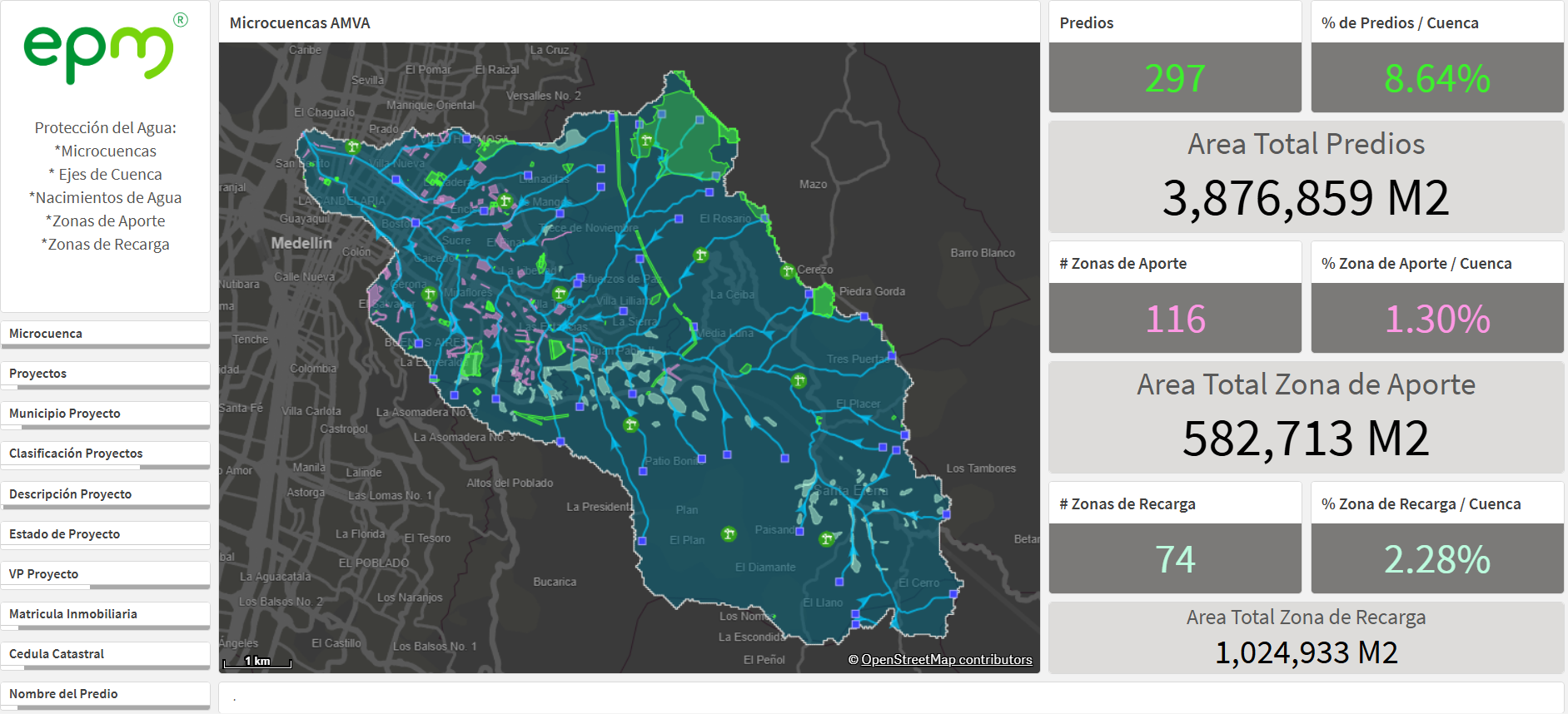
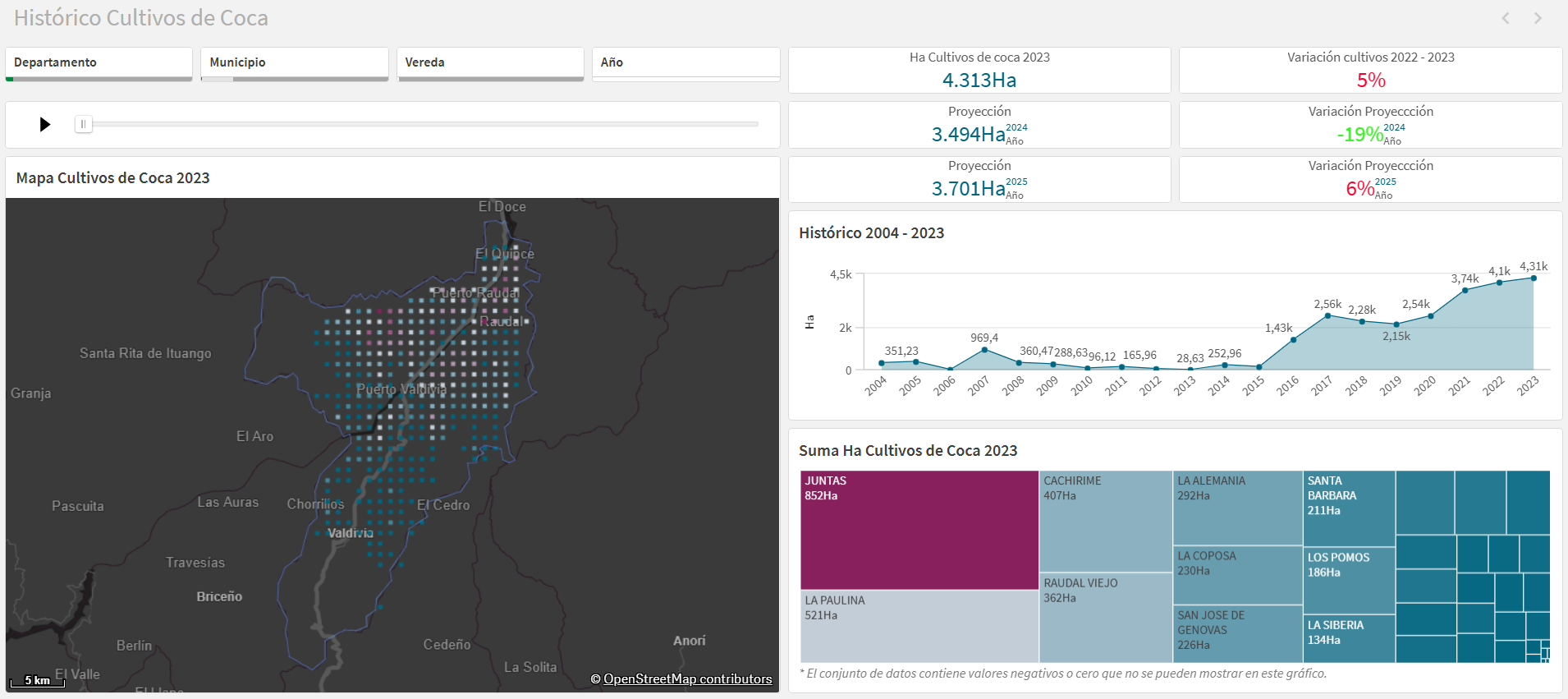 Images sourced from Grupo EPM, illustrating SIAE’s interface.
Seeing beyond security: how the SIAE evolved to be used by the entire corporation
The first version of SIAE launched with five applications and 120 indicators, covering the most urgent dimensions of security and context. But it grew into something much broader.
As the platform matured, new modules were added. Protest alerts updated weekly, municipal development plans, socioeconomic data layers, and hydrological information such as watersheds and recharge zones became part of the ecosystem. Internal EPM data was also expanded, linking projects and assets more directly to contextual information.
By 2025, SIAE had grown into an ecosystem of 17 applications, fed by more than 40 public sources and enriched with company data. What began as a tool for security monitoring had become a corporate intelligence platform. Security analysts still relied on it to assess risks, but planners, strategy teams, and project managers also used it to align projects with local priorities and anticipate potential conflicts before they escalated.
As a result of modelling SIAE data, the team developed a robotic desktop automation (RDA) that allows comprehensive security analysis reports for a territory to be generated in an average of 10.79 minutes, based on a specific geometry that can represent a project, work zone, or company infrastructure. This enables risk identification at a granular level — including neighbourhoods or rural communities — and allows this type of analysis to cover the entire infrastructure nationwide
From Reactive to Proactive
The impact of SIAE has been profound. An important metric for measuring its impact was the reduction of analysis time from 181 hours to an average of 10.79 minutes. Coverage also increased from 34% of projects and 19% of infrastructure sites analysed to 100% in both cases. The average cost per document dropped from between USD 80 and USD 2,667 to just USD 2.
Two use cases exemplify the public value of this system: the first relates to an analysis conducted for the city of Cartagena on streetlights and security conditions in public spaces; the second involves responding to an interruption in water supply affecting around 1 million people.
An analysis of streetlights in Cartagena’s green areas and beaches, based on the theory of perceived security in public spaces — which suggests insecurity can be linked to the quality of public lighting — enabled the study of historical and spatial crime data in these areas. The result was the identification of 158 zones with high crime rates and poor lighting, which were prioritized for intervention with the city’s mayor’s office as part of a broad public lighting upgrade plan.
The second case involved preparation for a five-day interruption of water and sewage service in four municipalities of the Aburrá Valley Metropolitan Area, due to modernisation and maintenance at one of EPM’s most important plants in Antioquia. This interruption, aimed at benefiting 703,000 households, required analysing how to support the population during the absence of this essential service — using water trucks, hydrants, and bagged water. SIAE made it possible to identify the sectors that would be affected and had complex socioeconomic and security conditions, focusing efforts there. This enabled the distribution of staff and resources in these neighbourhoods, ensuring five days of service without complications and minimizing the population’s exposure to the scheduled outage.
Today, SIAE is more than just a security tool: it is a way to view territories holistically. For EPM, it has meant safer teams, more resilient infrastructure, and a stronger relationship with the communities it serves. For other institutions, it offers a replicable lesson: by connecting data from different dimensions and building progressively, public organisations can turn complexity into intelligence and strengthen their ability to act responsibly.